Index
183,260 total views, 81 views today
 Plovdiv is the second largest and important city in Bulgaria. It is situated on both banks of Maritsa River in the Upper Valley at 42 ° 9 ‘north latitude and 24 ° 45′ east longitude, and the lowest point is at 160 m above sea level. The area is 101.981 square kilometers with population about 365,000 people.
Plovdiv is strategically important industrial, commercial, scientific, cultural and transportation-communications center on the Balkans region. The city is famous with the international fair, whose spring, autumn and other specialized exhibitions make it a center of economic and business. Plovdiv is a strategic railway junction and the airport “Plovdiv” recently established itself as an alternative to the airport “Sofia”.
Through the city are passing major road arteries, which since ancient times have associated the Orient with Europe, the Baltic and the Mediterranean, the Black Sea and Adriatic sea. Its unique location as an ancient crossroad has stimulated strong cultural and political influences from East and West civilizations but still maintained its cultural identity. The six hills give unique and picturesque beauty to the city, and the protected areas have preserved a considerable number of rare plant species. The Maritza River and the green hills form the specific climatic conditions – mild winters and hot, but humid summers. Climatic conditions and geographic location of the city have contributed to its positive growth in all historical periods.
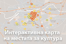
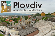
The preserved architectural, historical and cultural heritage have established the city as a major tourist center of Bulgaria. Plovdiv is older than Rome, Athens, Carthage or Constantinople, and is considered as a contemporary of ancient Troy. Today the town is built on the ruins of ancient cities and its culture has evolved from the legacy of many previous cultures.
Plovdiv municipality is the area limited from the road signs of the city and is managed administratively by majority elected mayor with a 4-year term. The mayor represent the executive local authority. The activities of the municipal administration is controlled and approved by the City Council.
For more effective management , the municipality is divided into 6 administrative regions – “Central”, “East”, “West”, “North”, “South” and “Trakia” – which are separated as municipalities with majority elected mayors and district administrations. Each region of the city is comparable to the number of population in the most regional centers.
Plovdiv is the administrative center of Plovdiv District, which occupies area of 5928 square kilometers. The district is divided into 16 municipalities with a total of 215 villages and 16 towns. The population is about 750 000 people. The northern part of the district is mainly flat with developed intensive agriculture. South is mountainous and here are developed the livestock, timber industry and tourism. In Plovdiv region are famous natural and historical sights, resorts and spa centers such as the picturesque Valley of Roses, spa centers in Hisar, Narechen, Assen medieval fortress, Bachkovski monastery, Arapovo Monastery, tomb Starossel and others. The district covers the central part of Southern Bulgaria. On the North the district includes the southern slopes of the Balkan Mountains and the central part of the lower ridge of the Mountains. On the South , Plovdiv region enters the Rhodope Mountains.
Plovdiv is the center of the South Central region, which includes Plovdiv, Pazardzhik, Smolyan, Haskovo and Kardzhali.
183,261 total views, 82 views today